The Silurians
The
pages below are under development and will
be updated on a regular basis.
Click on smaller images for larger view, use back arrow for return.
All images are from the author's collection unless otherwise indicated.
The Silurians are here
The geology of Upper Wharfedale is very similar to that of Western Penyghent and the same stratigraphical column adequately illustrates both areas. Whilst the strata beneath the limestones, the basement rocks, are well exposed in Ribblesdale, this is not the case in Upper Wharfedale. This is not to say they are not present, they certainly are and this was demonstrated in a British Geological Survey borehole at Outgang Laithe near Chapel House. At an altitude of 263m, the bore passes through the Kilnsey Limestone, the Kilnsey Limestone with Mudstones and the Chapel House Limestone to pass into Lower Palaeozoic rocks at a borehole depth of some 90m. The borehole was completed at a depth of 107.12m (= altitude 155.88m). These Lower Palaeozoic (Silurian) rocks are described as 'Sandstones and siltstones, grey-green, fine laminated, fine arenite sandstones and interbedded siltstones.' Assuming a uniform surface to the Silurian rocks then the basement rocks are concealed some 27m below ground level in the valley bottom (c183m) in that area. Considering the very uneven topography of the basement rocks observed in Ribblesdale, Chapel-le-dale and elsewhere, it seems reasonable to assume that the topography of the basement rocks in Upper Wharfedale is also very uneven. Further to that, following speculation in some of the caving community over many years, it seems reasonable to propose that these basement rocks are responsible for the many, and sometime quite sizeable, resurgences seen along or close to the valley bottom in Upper Wharfedale.
These include Black Keld, White Keld, Davy Keld, Braith Gill, Brow Well, the Kilnsey Risings and Robin Hood’s Cave.
The argument is that the Wharfedale glacier gouged out the valley bottom to some depth right through the limestone sequence and into the Silurian basement rocks. If this was the case then one would expect to find fragments of the Silurians in the glacial drift down-valley from that point. If the assumption that the topography of the basement rocks is uneven is correct then the basement rocks would be more likely to have been torn out in substantial amounts and sizes. An uneven topography would also account for a variation in the relative altitudes of major resurgences in the dale. Furthermore, if these ‘erratics’ have been deposited on the decay of the ice and thus travelled a very short distance they are likely to be little rounded or not rounded at all, compared to the much travelled limestone, sandstone and gritstone cobbles abundant in the drift. Having got to this point the logical procedure is to test this hypothesis by looking into the work of earlier researchers and also to go out into the field and look for some Silurian rocks in the glacial drift of Upper Wharfedale.
Images of many of the Silurians discussed in this section can be viewed by using the links to Silurian Picture Galleries at the bottom of the section.
John Roche Dakyns
In the Yorkshire Geological Society Proceedings Vol. 6, dated 1871-1877, John Roche Dakyns, a geologist on the staff of the Geological Survey, wrote about foreigners, Silurian glacial erratics, that could be found scattered amongst other glacial deposits in Wharfedale. This may be a misconception as, strictly speaking, the SiIurians would be foreigners only if they came from another area. However, to quote Daykins:
"Some years ago ... I called attention to the occurrence of SiIurian boulders in a part of Wharfedale..."
"... in Wensleydale .. no boulders are found except of Carboniferous rocks: the same is the case in Coverdale, Bishopdale, Semmerdale and Nidderdale ... in Dentdale too.. Littondale.. and also with the single exception I am going to describe, in Wharfedale."
'Between Burnsall and Chapel House, however, Silurian erratics are very plentiful. It is true they have been mostly cleared off surface of the land and built into walls, where they are plentifully used as 'throughs', but in the walls they are numerous, so much so as to strike the attention, some boulders, however, still remain on the surface, and an examination of a beck course cut through drift will readily disclose them in the drift.."
Dakyns goes on to discuss potential sources of these erratics including the possibility of having been brought in by ice movements from well known sources in Ribblesdale. He convincingly shows that this is an improbable proposition due to conflicting ice movements and then gives a more plausible explanation for the origin of the erratics.
"were we able to remove the covering of drift and alluvium, that conceals the solid rocks of the valley bottom near Kilnsey, we should find Silurians in place in the valley bottom... it is noteworthy that some strong springs break out at the foot of Kilnsey Crag ... also in a certain part of Littondale ... two strong springs break out at, or near, the base of the limestone scars."
"Briefly, I would suggest ..Silurian rocks exist in the valley bottom beneath a covering of superficial detritus and it was from this outcrop that the SiIurian boulders …. were derived."
Arthur Raistrick
The late Arthur Raistrick, mining engineer, geologist, archaeologist and pioneer in industrial archaeology, took a great interest in glacial phenomena, in fact his first published paper of 1926 was on the glaciation of Borrowdale in the Lake District, and his abiding interest in the effects of glaciation resulted in many more writings in the same vein. I was reminded by Edward Whitaker that one of Raistrick’s achievements, in cooperation with the Dalesman Press, was a series of simple affordable booklets illustrating for the general reader a wide range of topics including Dales buildings, Pennine walls, dew ponds, Dales forests, green roads and byways, Malham and Malham Moor, Grassington and Upper Wharfedale and many others including ‘The Ice Age in Yorkshire’. From shortly after his marriage in 1930, he lived with his wife Elizabeth at Linton, right in the heart of this Silurian terrain, for the rest of his life. He was thus well qualified to make observations on the local geology.
Raistrick had clearly studied Dakyns work and, in 1931, wrote in the Yorkshire Geological Society Proceedings Vol. 12, his own observations with particular regard to the presence of SIlurian erratics in Wharfedale.
“At the south-west end of this moraine (the Conistone moraine), sections are exposed in a large gravel pit near Chapel House Lodge and here the drift, though still almost entirely Carboniferous material, contains a small percentage of a new rock, a green Silurian grit. From this point down the dale and southward across the lower part of Threshfield moor (up to 900ft OD) into the Cracoe-Linton valley, these erratics become very common, and often of a large size”
“The very limited distribution of these erratics would suggest that the SIlurian rocks were exposed for a short time in the Ice Age by ice erosion and not by ordinary river erosion as pebbles are absent from any of the gravels south of Burnsall.”
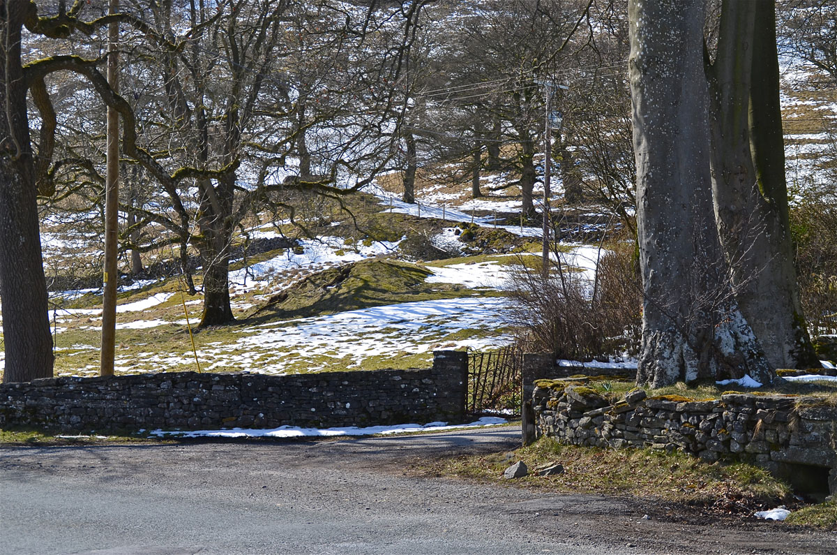
Above: remains of moraine heap near Chapel House referred to by Raistrick, somewhat overgrown when photographed on March 30, 2013.
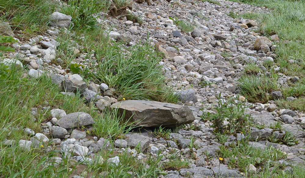
There is of course the possibility that the Silurian rocks may be exposed in the river bed below the the cascades of Mill Scar Lash where the geology encompasses some of the lowest beds (Arthurton et al 1988). It seems unlikely Arthur Raistrick would have overlooked this possibility and he makes no mention of such an occurrence.
The Silurian erratics
Having seen some measure of agreement above, the logical step is to have a look for Silurian erratics in the field and, if the above arguments are correct, then one would expect these erratics, having travelled such a short distance, to be quite distinguishable from other glacial deposits, the limestone, sandstone and gritstone boulders which are invariably well rounded.
After a brief look for some 'foreigners" around Mill Scar Lash in late May (20th) and finding none, we (my wife and I) went round to Kirk Bank (around NGR 978652).
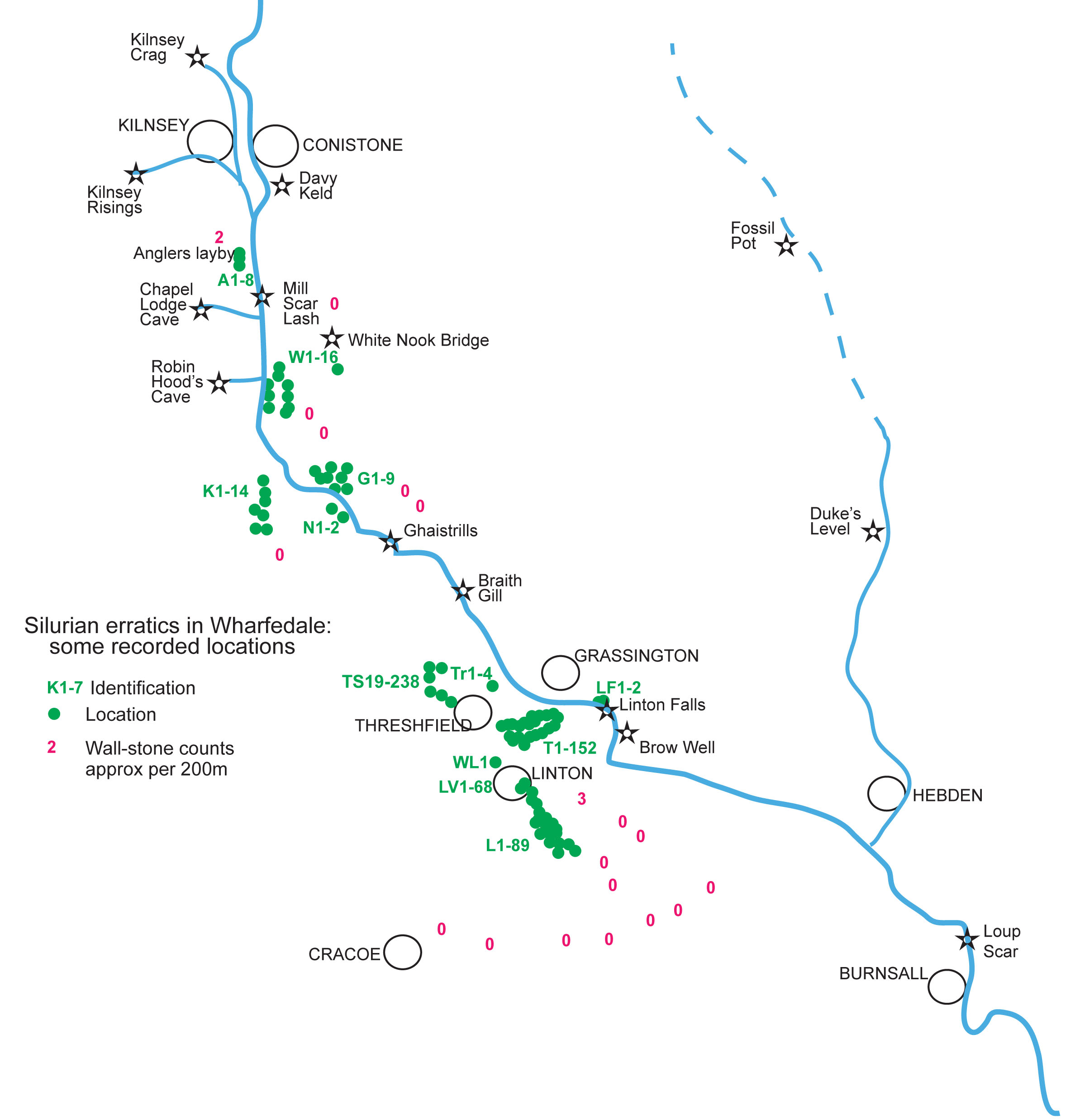
Lo and behold! There they were - at least seven of them, quite distinguishable from the bulk of the material forming the wall stones. They were each tested with a spot of dilute HCL because some black limestone cobbles from the higher beds tend to resemble some of the erratics and vice versa: others are quite distinctive – see Picture Gallery 4.
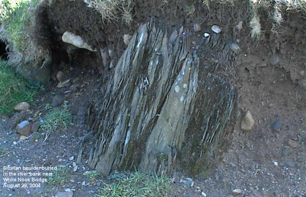
Two weeks later (June 2) on the riverside in the Netherside Gorge behind Netherside Hall we almost fell over a large heap of Silurian erratics (N1), and the following weekend yet another large block was found a short distance away, well embedded in the boulder clay by the river bank (N2) (NGR 981651).

Silurian N1: a stack of large Silurian slabs half buried in the river bank and probably exposed in recent floods. Scaling stick is 0.5m long.
An odd looking rock was reported by Edward Whitaker so we paid a visit to the other side of the river on June 24 to find a good number of by now easily recognisable Silurian erratics. Edward’s “odd-looking” rock (G2) was a fine specimen which had clearly been washed out of the river bank in a recent high flood. On subsequent visits many more erratics were seen including some very large rocks embedded in the footpath along the riverside (NGR around 981651). A fine specimen (W13) was then spotted lurking in a wall footing near White Nook Bridge (NGR 981661).
Following up Raistrick’s ideas we examined some walls around Linton and discovered that the Silurians (L1-22) (around NGR 002623) were quite numerous in certain walls on the lower ground but apparently absent on the higher ground. Some preliminary estimates were made of occurrences on walks through Linton but several problems became apparent. We could only examine readily accessible wall sections alongside public footpaths and roadsides and, in some areas, along Well Lane for instance, heavy growths of mosses and lichens conceal the nature of the wall-stones. Another location between Grass Wood and the river, which had first been visited in 2004 with Chris Camm, now revealed several Silurians right on the river bank (W1-16) (NGR 980659) and no doubt more will be visible when water levels are much lower.
There have been a number of reports of sightings of SiIurian erratics in the dry-stone wall alongside the Angling Society's layby (NGR 978665) 400m north of Chapel House Farm. Only eight specimens (A1-8) could be found over a wall length of some 500m and as these were confined to the immediate vicinity of the layby it seems likely that these were brought in from the gravel pit opposite the farm when the roadside wall was rebuilt in the 1950's. It was from the gravel pit that Raistrick first recorded green Silurian grit (see above).
On a walk around the Threshfield area on November 4, 2012, Silurian erratics were found to be abundant in the field walls and in the roadside walls. More than 150 (T1-152) specimens were recorded on a three kilometre walk (NGR 993633 to 999632).
Silurian G2: Edward's 'odd-looking rock' readily identifiable amongst other rocks on the riverside.
Some 200 or so Silurian erratics of varying shapes and sizes were recorded along the green lane between Tarns Lane (B6265) and Linton village and into the village (9853 6236 to 9969 6272) on April 21, 2013.
The sections 'Picture Gallery 4a', 'Picture Gallery 4b' and 'Picture Gallery 4c', available as downloads at the end of this section, illustrate most of the Silurian erratics recorded to date, May, 2013, but many more can be seen, specifically in the walls and buildings of Linton village. Undoubtedly there are large numbers concealed in wall footings, in overgrown or collapsed wall sections, and, buried in the great mounds of glacial drift but what we see today in the walls are those picked off the fields many generations ago. Having examined only a small proportion of these walls it seems highly likely that the Silurians recorded in these pages represent considerably less than 5% of the total number that may be visible in the area.
Have a look at some images of the Silurians around Netherside, Grass Wood, White Nook Bridge, Linton Falls, Kirk Bank, Anglers' Layby:
Silurians images on Picture Gallery 4a.
use backspace key to return
and then look at more Silurian images around Linton fields and Threshfield fields:
More Silurians images on Picture Gallery 4b.
use backspace key to return
further views can be seen from the Tarns Lane - Linton area on:
More Silurians images on Picture Gallery 4c.
use backspace key to return
and in the fields between Threshfield and Skyrethorns:
More Silurians images on Picture Gallery 4d.
use backspace key to return
References
Arthurton R S, Johnson E W and Mundy D J C 1988. Geology of the country around Settle. Mem. Br. Geol. Surv., Sheet 60 (England and Wales).
Dakyns J R 1877a Notes on the Glacial Phenomena of part of Wharfedale, near Grassington, from my mss. Written in 1878. by J. R. Dakyns, M.A. Proceedings of the Yorkshire Geological Society 1871-1877 Vol 6, pp 159-163
Dakyns J R 1877b On Silurian Erratics in Wharfedale. by J. R. Dakyns, Esq. Proceedings of the Yorkshire Geological Society 1871-1877 Vol 6, pp 159-163
Dakyns J R 1893 Glacial Phenomena of Wharfedale between Bolton Abbey and Kettlewell by J. R. Dakyns Proceedings of the Yorkshire Geological Society 1893 vol 12, pp 299-305
Raistrick A, 1930 The Glaciation of Wharfedale, Yorkshire (Silurian erratics) Proceedings of the Yorkshire Geological Society XXII, pp 9-30
Raistrick A, 1933 The Glacial and Post-Glacial Periods in West Yorkshire Proceedings of the Geological Association 44, 228-269
Any
shortcomings in the text are entirely my
own.
If you would like to get in touch or add information, there is an email
address:
mudinmyhair@btinternet.com
Steve Warren
Website created by WarrenAssociates 2012
Website hosted by Tsohost
Copyright © Steve Warren 2012